Pothamedu View Point |
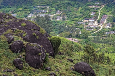
Located at a distance of 4.5 kms from Munnar, the Pothamedu View Point has a majestic beauty attached to it. The coffee, tea and cardamom plantation located at the Pothamedu View Point appears like a bouquet of natures scenic beauty. For those who love adventure sports, the Pothamedu View Point offers hiking and trekking opportunities. One can also view the Idukki Arch Dam which is situated 60 kms from Pothamedu View Point when sky is clear. Pothamedu View Point has a panoramic view of adjoining valley and river Muthirapuzha. It has an ideal view for photographers as well as leisure travellers. August to May is the preferable time to visit the Pothamedu View Point. Vehicles crawling up the serpentine road from Kochi appear to be minute when viewed from the Pothamedu View Point.
|
Lock Heart Gap |
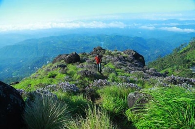
Lock Heart Gap is a popular destination frequented by tourists. Lock Heart Gap, located in Mattupatty, is about 13 km from Munnar on the Munnar – Madurai National Highway. Lock Heart Gap is famous for its scenic trails through dense forests. Rare species of flora and fauna can be viewed while taking these trails in to the jungle. Lock Heart Gap is considered as photographer’s paradise due to its peculiar location amidst the hill ranges of Western Ghats. The view of lush green valleys, rolling hills, grasslands, etc. along with descending clouds gives a breathtaking experience. This place is also famous for its sprawling evergreen tea estates, which are shrouded in mist. Lock Heart Gap is considered as an ideal place for trekking, mountaineering and nature walks. Kundala tea plantations, Kundala Dam and Lake are the nearby attractions.
|
Cheeyappara Falls |
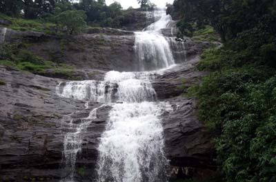
Cheeyappara Waterfalls is a famous destination of tourists visiting Munnar. Munnar, known as Swiss of South India, has a varying terrestrial terrain that consists of water cascades, rolling hills, verdant valleys, dense forests and tea, coffee and spice plantations. Cheeyappara Waterfalls is one among the many waterfalls of Munnar, which is located at a distance of about 38 km from the town centre. This waterfall is situated in between Adimali and Neriamangalam, adjacent to Munnar to Kochi Highway (NH 49). Cheeyappara Waterfalls is considered among the best waterfalls in the State of Kerala. Cheeyappara Waterfalls runs down from a rocky slope in seven steps. The waterfalls gain its beauty during and after monsoon months of June, July and August and it becomes impossible to reach the bottom of the falls. The water of Cheeyappara Waterfalls does not dry up even in summer months.
|
Anamudi Peak |
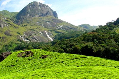
Anamudi or Anai Mudi or (Malayalam pronunciation: [aːnɐmʊɖi]) is a mountain located in the Indian state of Kerala. It is the highest peak in the Western Ghats and South India, at an elevation of 2,695 metres (8,842 ft), and a topographic prominence of 2,479 metres (8,133 ft). The name Anamudi literally translates to "elephant's forehead," a reference to the resemblance of the mountain to an elephant's head. The first recorded ascent of Anamudi was by General Douglas Hamilton of the Madras Army on May 4, 1862,[citation needed] but it is likely that there had been earlier ascents by local people.Anamudi is the highest peak in the Western Ghats in India, having an elevation of 2,695 metres (8,842 ft). Anamudi is also the highest point in South India.[8] This gives Anamudi its relatively large topographic prominence of 2,479 metres (8,133 ft), the associated key saddle being over 2,000 kilometres (1,200 mi) away at 28°35′20″N 76°27′59″E in Haryana state just to the west of Delhi. The peak is the highest point of the Periyar river basin.
|
Chinnara Wild Life |
Chinnar Wildlife Sanctuary (CWS) is located 18 km north of Marayoor on SH 17 in the Marayoor and Kanthalloor panchayats of Devikulam taluk in the Idukki district of Kerala state in South India. It is one of twelve wildlife sanctuaries among the protected areas of Kerala. It is under the jurisdiction of and contiguous with Eravikulam National Park to the south. Indira Gandhi Wildlife Sanctuary is to the north and Kodaikanal Wildlife Sanctuary is to the east. It forms an integral part of the 1,187 km2 (458 sq mi) block of protected forests straddling the Kerala-Tamil Nadu border in the Annamalai Hills. The Western Ghats, Anamalai Sub-Cluster, including all of Chinnar Wildlife Sanctuary, is under consideration by the UNESCO World Heritage Committee for selection as a World Heritage Site.CWS is located between latitude 10º15' - 10º21' N and longitude 77º5' - 77º16' E. The Munnar – Udumalpet road SH 17 passes through the sanctuary for 16 km and divides it into nearly equal portions. Average annual rainfall is only 500 mm, spread over about 48 days, because it is in the rain shadow region of the southern Western Ghats.
|


